
Gilgit-Baltistan Mountains & Glaciers
Northeast Pakistan
Baltistan April 2014:
Beginning in Islamabad, we were lucky to get a flight to Gilgit, Baltistan. PIA schedules daily flights to Gilgit, but most flights at this time of year are canceled.

It was cloudy and doubtful that the flight would depart, but a small clearing in the clouds gave us an opportunity. Nanga Parbat, east of Gilgit, at just over 8000 meters, is one hurdle since the clouds tend to gather over it. The next hurdle is Rakaposhi at 7800 meters north of Gilgit, which creates its own set of clouds. But with luck and a good pilot, we made it through passing the western end of the Himalayas, into the middle of the Karakoram, and met the eastern side of the Hindu Kush.

Gilgit is home to the Karakoram International University and is the administrative headquarters for Baltistan. We walked across a hanging bridge to a tunnel near the campus, and nearby were stones covered with petroglyphs.

Rakaposhi Peak sits above the hills outside of Gilgit.
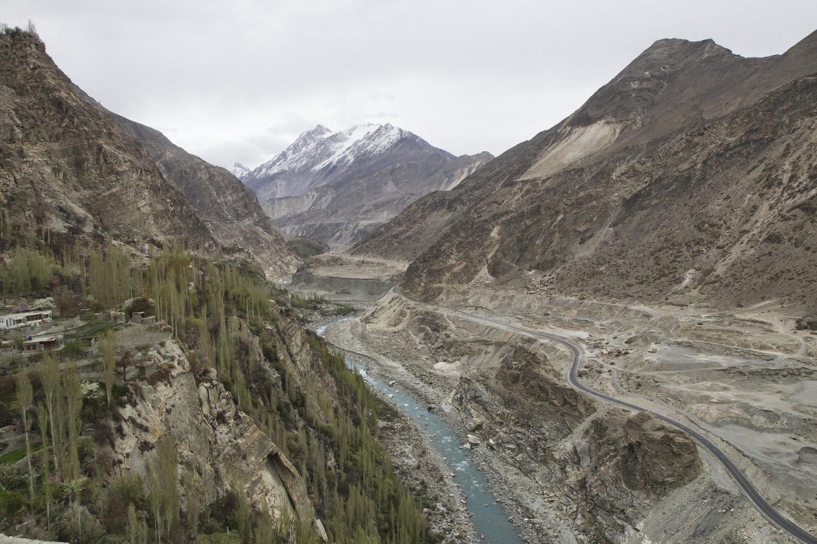
 Rakaposhi Peak is part of the Karakoram mountains and has the longest vertical rise of any mountain in the world, 6000 meters straight up. The glacier head is in the Nagar Valley. Before going north toward Rakaphosi, there is one glacier to visit in Bagrot Valley.

Rakaposhi Peak is part of the Karakoram mountains and has the longest vertical rise of any mountain in the world, 6000 meters straight up. The glacier head is in the Nagar Valley. Before going north toward Rakaphosi, there is one glacier to visit in Bagrot Valley. |
| Bagrot Valley |

Bagrot Valley is east of Gilgit after Oshikhandas, following the Gilgit River to the junction with the Bagrot River. The Bagrot Glacier sits at the end of the valley (where the snow is in the photo).

A shaman was called in to help disperse people's fears about a GLOF. In his trance, he said that there was danger and they needed help.

The people are afraid of a large GLOF event. They try several types of protection, from the predictions of a shaman to the structures they build in the river to prevent the river from taking their land and sweeping away villages. Bagrot is getting organized with a flood early warning system and structures that might slow the water down. They are at risk and seek help from the Pakistan government to help them prepare.

Back on the road toward Hunza Valley, we were going to enter Karimabad. The problem was that the road was blocked by protesters. They were angry about the loss of a subsidy on wheat, their staple food. With the road blocked in about 4 spots, we were unsure how we would make it to Karimabad. The strongest point was where the protesters put up a stone barrier across the road and a tent. They were very polite and eventually said we could pass because we were their guests.


Taking cars across the lake was quite a sight, not to mention dangerous.

A trip across the lake in the wooden boats took about 45 minutes. If one were lucky to find the expensive speed boat, it would take 20 minutes, but if the weather changed and the wind picked up, none of the boats would go. Getting cars onto the boats was quite a feat, and the wobbling trip across was quite unnerving.
 At the other end of the lake is a village called Gulmit. This village and all villages north have been cut off from supplies since the landslide. They now have limited access to markets. It was too expensive and time-consuming to cross the lake to buy and sell in the larger markets toward Gilgit. The village below was submerged before the water was drained.


 Passu is a beautiful place with towering craggy mountains. Below the river is full of silt from many washout floods that come down from the Shimshal valley. There are very few trees and many stones.


 The fields of Borith are dry, and the fruit trees will not survive without water.


The people are afraid of a large GLOF event. They try several types of protection, from the predictions of a shaman to the structures they build in the river to prevent the river from taking their land and sweeping away villages. Bagrot is getting organized with a flood early warning system and structures that might slow the water down. They are at risk and seek help from the Pakistan government to help them prepare.

Back on the road toward Hunza Valley, we were going to enter Karimabad. The problem was that the road was blocked by protesters. They were angry about the loss of a subsidy on wheat, their staple food. With the road blocked in about 4 spots, we were unsure how we would make it to Karimabad. The strongest point was where the protesters put up a stone barrier across the road and a tent. They were very polite and eventually said we could pass because we were their guests.

We drove a back road to avoid more protesters. It was beautiful, winding through the apricot, apple, and cherry trees. Closer to Karimabad, the 800-year-old Baltit Fort came into view.

Baltit Fort

The view north is of more mountains and glacier valleys, also the Altit Fort, which is slightly older than the Baltit Fort. The mountains around the Hunza valley are curtained with clouds. There are no views of the lovely jagged peaks, where one long pointed peak is named the "Lady's Finger".

Hunza Valley is a place most people visit. Besides the Altit and Baltit Forts, there is Cafe de Hunza - for the best coffee and walnut cake in the Karakoram.

The view up the valley from Hunza.

Less than 10km from Karimabad, the road meets a large landslide that in 2010 covered the Karakoram Highway, blocked the Hunza River, and flooded many homes, shops,s and hectares of land. The lake kept filling and flooded 5 villages, displacing and affecting thousands of people. Two years later, the blockage was blown up, and the lake began draining down to half its previous size, from over 20km in length to 11km.
Hunza Valley is a place most people visit. Besides the Altit and Baltit Forts, there is Cafe de Hunza - for the best coffee and walnut cake in the Karakoram.
The view up the valley from Hunza.
Less than 10km from Karimabad, the road meets a large landslide that in 2010 covered the Karakoram Highway, blocked the Hunza River, and flooded many homes, shops,s and hectares of land. The lake kept filling and flooded 5 villages, displacing and affecting thousands of people. Two years later, the blockage was blown up, and the lake began draining down to half its previous size, from over 20km in length to 11km.
 |
| Opening where the lake was drained. |
 |
| View of Attabad Lake |
Taking cars across the lake was quite a sight, not to mention dangerous.

A trip across the lake in the wooden boats took about 45 minutes. If one were lucky to find the expensive speed boat, it would take 20 minutes, but if the weather changed and the wind picked up, none of the boats would go. Getting cars onto the boats was quite a feat, and the wobbling trip across was quite unnerving.
At the other end of the lake is a village called Gulmit. This village and all villages north have been cut off from supplies since the landslide. They now have limited access to markets. It was too expensive and time-consuming to cross the lake to buy and sell in the larger markets toward Gilgit. The village below was submerged before the water was drained. |
Gulmit is an ancient village that caters to tourists. We had lunch at the Marcopolo Inn and were welcomed with singers and a buffet lunch. The community came to discuss their problems with hanging glaciers, threats from floods, landslides, and loss of water from retreating glaciers.
The glaciers are debris-covered and hang over the valley. One man said he had trouble sleeping at night, wondering if the glacier would fall down on them.
The families below the glacier grow potatoes and wheat. Orchards are full of apricots, cherries, apples, and walnuts. They struggle to sell what they grow because Attabad Lake has blocked market opportunities.
Passu is a beautiful place with towering craggy mountains. Below the river is full of silt from many washout floods that come down from the Shimshal valley. There are very few trees and many stones.
Passu Glacier is near Borith Lake but sits below the lake on the other side of a ridge. People used to irrigate with water from the glacier, but now it is below their fields. Borith Lake is saline and unusable.
Passu Glacier is called a female glacier because it is snow-white on the surface.
Male glaciers are debris-covered on the surface. The melting of the Passu Glacier has created several interconnected lakes. Some people believe that if you remove ice from a female glacier and put it with a male glacier, a new glacier will form.


Peaks peaking over a ridge in Sost, where we stay before going to Khunjerab National Park (KNP). Sost is a dry port and has all the elements of a frontier town. Chinese goods have flooded the town.
At the first stop before entering the park, a young snow leopard is kept in a small cage. It was rescued from an avalanche when it was a cub. It paces up and down. The stress of living next to the road is apparent. Hopefully, WWF will move it to a better location where it might eventually re-enter the wild areas.
There are many Ibex in the park; they make amazing jumps from one rocky area to the next, leaping across large gaps.

 The upper part of KNP was cold and windy in April, and the road was snow-packed to the Chinese border. There were a few guards on duty from the Chinese side, but none on the Pakistani side.


It is a wonderful snow-covered scene with jets streaming overhead on some unknown flight path and wide open yak pastures that will green up when the snow melts.


 Traveling back through Karimabad, we turned to the east toward the Nagar Valley. This is the opposite side of the Hunza valley and is predominantly a Shia area. They are also facing many changes from melting glaciers.

Hopar Glacier is male; very dirty with debris. It seems to both retreat and advance, which is puzzling. Two children greeted us with flowers, and the small boy sang from the Koran before we joined them for lunch.

 Rakaposhi (7788m) and Diran (7226m) peaks challenge Karakoram climbers, and for the Minapin village below, where the glaciers from these two massive peaks meet. Diran Guesthouse provided a lovely garden lunch for us, and again, a community full of concerns for their future water supply and threats from the glaciers.

Sost community was very welcoming. They organized a full program with children performing skits, songs, and young school girls dancing. They brought in officials to discuss their climate change concerns.

 |
| A Shia village near the Hopar Glacier |
Hopar Glacier is male; very dirty with debris. It seems to both retreat and advance, which is puzzling. Two children greeted us with flowers, and the small boy sang from the Koran before we joined them for lunch.

Back to Gilgit with our bags full of dried apricots, cherries, walnuts, and almonds, it will be remembered as a great trip.


It looks like clouds are forming in the sky just in time for our departure, and maybe a repeat of the trip into Gilgit, but I think we will make it back to Islamabad.
 Salama lakum.
It was also summed up nicely by the quote on the wall near Attobad Lake.


Comments
Post a Comment