
Langtang Then 2015 and Now 2016
Prologue:
On April 25th, 2015, within minutes after the 7.8M earthquake hit, a large overhanging glacier on Langtang snapped and tumbled down, bringing tons of ice and rock from near the top of a 7000m peak to the valley below. This was quickly followed by an enormous pressure wave that flattened trees on the opposite side of the valley. The valley was buried, and no one had a chance to escape. It was peak season for tourism - all the hotel owners, their families, and tourists were there. Walking through this extremely damaged and haunting valley makes your heart ache. I felt like I had landed on the moon, but knew that 20 meters below the surface, many were buried under the rubble. Let's go through the valley now. Below is a photo of the valley from a helicopter. A new settlement is slowly starting on the north side of the slide.
Around the Bend:
It takes about 6 to 7 hours to get to Syabru Besi from Kathmandu, where the Langtang trek starts. From Dhunche, the road is pretty rough. Many large lorries and container trucks travel the route to collect goods from China and deliver equipment for the hydropower station.

Then there are breakdowns.... in the middle of the road, so when everything stops, the best thing to do is walk for a while.


Many people still live in temporary shelters one year after the earthquake in 2015. There has been little help or resources provided to rebuild.

People in this area are of Tibetan origin, and others are Tamang or Sherpa.


People in this area are of Tibetan origin, and others are Tamang or Sherpa.

New fiber optic cable is being laid along the road by workers who will never be able to afford to use it.


The public toilets at Syabru Besi are off-kilter from the earthquake. This is at the point where one trail goes east, crossing the suspension bridge, heading east along with the Langtang Kola toward Lama Hotel, and the other north toward a village called Khangjung.

It is a very steep walk to the top of the bhanjyang.


This was our lunch stop.

There are three hotels in Khangjung - either for spending the night or just for lunch, depending on how early you get on the march.

An old abandoned house in the village. From the beautiful details on the windows, it looks like a place that used to have some life but no longer does.

The village has a small Gompa that was damaged by the earthquake, but it still has some lovely paintings and is hopefully repairable.


Higher up from Khangjung, a new lodge is being built that has great views.

A village woman is planting her potatoes and hopes it will rain soon. Everything is dry, and continuous forest fires are making the whole region hazy. Many landslides are visible on the mountain across the valley.

A Himalayan Griffin glides over our heads.
Our 1st night is at Syarpa Gaun. There is an option of camping or staying in a room. The rooms were very good, and some had attached bathrooms. A real luxury. There is no photo of the hotel.... sorry.

Our lodge-keeper was a thin Sherpa woman who lost her husband, son, and home in the Langtang Valley. She said she could not go there. She had nothing left and managed the lodge.
A Green-backed Tit has caught a spider for breakfast.

The poor donkey doesn't have such a good breakfast - just a tough piece of bamboo.


Our team from ICIMOD flew a drone over the river to get some photos of the river flow.

As we gain elevation, the rhododendrons are blooming in lovely colors - pinks, white and occasionally a red.

The path is not always easy as we walk across numerous landslides that took place on the day of the earthquake.
Meeting sites destroyed by landslides are hard to see, knowing that people no longer have their source of livelihood and may have even lost their lives in the earthquake.

 Carrying heavy loads is part of life in the mountains, and animals and people need to eat.


It is a very steep walk to the top of the bhanjyang.


This was our lunch stop.
There are three hotels in Khangjung - either for spending the night or just for lunch, depending on how early you get on the march.
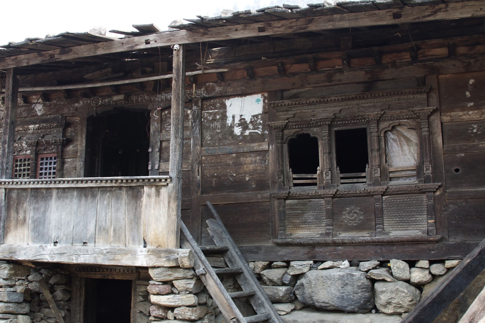
An old abandoned house in the village. From the beautiful details on the windows, it looks like a place that used to have some life but no longer does.

The village has a small Gompa that was damaged by the earthquake, but it still has some lovely paintings and is hopefully repairable.


Higher up from Khangjung, a new lodge is being built that has great views.

A village woman is planting her potatoes and hopes it will rain soon. Everything is dry, and continuous forest fires are making the whole region hazy. Many landslides are visible on the mountain across the valley.

A Himalayan Griffin glides over our heads.

Our 1st night is at Syarpa Gaun. There is an option of camping or staying in a room. The rooms were very good, and some had attached bathrooms. A real luxury. There is no photo of the hotel.... sorry.

Our lodge-keeper was a thin Sherpa woman who lost her husband, son, and home in the Langtang Valley. She said she could not go there. She had nothing left and managed the lodge.

A Green-backed Tit has caught a spider for breakfast.

The poor donkey doesn't have such a good breakfast - just a tough piece of bamboo.


Our team from ICIMOD flew a drone over the river to get some photos of the river flow.

As we gain elevation, the rhododendrons are blooming in lovely colors - pinks, white and occasionally a red.

The path is not always easy as we walk across numerous landslides that took place on the day of the earthquake.

Meeting sites destroyed by landslides are hard to see, knowing that people no longer have their source of livelihood and may have even lost their lives in the earthquake.
 Carrying heavy loads is part of life in the mountains, and animals and people need to eat.
 Our group of porters also carries heavy loads and stops to rest before the next sleeping spot.

At Tangshyap, we stop to camp - a few lodges are being rebuilt. An old man recovered a prayer wheel from some of the ruined houses and puts in next to the trail.

Rufous-vented Tit above and Fire-tailed Sunbird are a few of the numerous birds feeding on the rhododendrons here.

Our porters, all dressed in their warmer clothes as we reach 3000m, are happy to pose. This is our campsite for our 2nd day of walking.
The snow peak lining the darkened hill above is Langtang Lirung. This was where the huge avalanche/landslide came from that buried Langtang Village.


On the opposite side are the trees that were blasted to the ground by the wind force from the landslide.

Above Langtang Village area places that were completely destroyed still stand within the boulders, unlike those in the middle of Langtang Valley below.

The actual area of Langtang Village lies below the rocky rubble, maybe by as much as 60m in some places. Only one hotel survived because it was under a large overhanging stone. Now waterfalls cascade down the rock front that was shaved off by the glacier and debris fall. Walking here, one's heart feels very heavy. It is impossible to imagine that underneath was a thriving village.

Memorial Wall

There are lists of all the people who died that day. It was incredibly sad!

Helicopters bring in large items that cannot be carried by donkeys or porters. A helicopter, recently donated by an NGO, was destroyed after it flipped while landing in the wind.

People say the Nepali people are resilient - these men are rebuilding in the Langtang Valley. I think it is a necessity - they really have nothing else, and they hope that tourists will slowly return.

Beautiful spring Iris.

One tough-looking yak with horns askew relaxes among the wild iris beds.

A view of the valley we need to reach.

A prayer wheel is turned by a small stream on the way to Kyanjing Gompa.


On the opposite side are the trees that were blasted to the ground by the wind force from the landslide.

Above Langtang Village area places that were completely destroyed still stand within the boulders, unlike those in the middle of Langtang Valley below.

The actual area of Langtang Village lies below the rocky rubble, maybe by as much as 60m in some places. Only one hotel survived because it was under a large overhanging stone. Now waterfalls cascade down the rock front that was shaved off by the glacier and debris fall. Walking here, one's heart feels very heavy. It is impossible to imagine that underneath was a thriving village.

Memorial Wall

There are lists of all the people who died that day. It was incredibly sad!

Helicopters bring in large items that cannot be carried by donkeys or porters. A helicopter, recently donated by an NGO, was destroyed after it flipped while landing in the wind.

People say the Nepali people are resilient - these men are rebuilding in the Langtang Valley. I think it is a necessity - they really have nothing else, and they hope that tourists will slowly return.

Beautiful spring Iris.

One tough-looking yak with horns askew relaxes among the wild iris beds.

A view of the valley we need to reach.
A prayer wheel is turned by a small stream on the way to Kyanjing Gompa.

At 3700m, we walk through a wetland on the climb up to Kyanjing Gompa that sits at 3870m.

Our ICIMOD team works to detect markers on the glaciers using a drone.

Early morning is the launch of a thermal detection drone that will pick up information from tags placed on a glacier further up the valley.

The device circles around a preplanned route, taking photos, returning, and collecting data. This data will help researchers determine the temperature effects of the debris that covers many glaciers.


Snow pigeons disturbed by the drone fly up over the rocks. Walking to the ridge where the drone is controlled from, we have a good view of a glacier lake.


Our ICIMOD team works to detect markers on the glaciers using a drone.

Early morning is the launch of a thermal detection drone that will pick up information from tags placed on a glacier further up the valley.

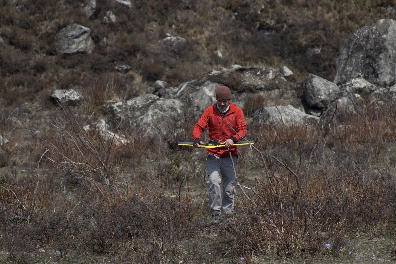
The device circles around a preplanned route, taking photos, returning, and collecting data. This data will help researchers determine the temperature effects of the debris that covers many glaciers.

Snow pigeons disturbed by the drone fly up over the rocks. Walking to the ridge where the drone is controlled from, we have a good view of a glacier lake.
The yaks find it hard to understand why we are there as they come up to graze in the pasture.


There are two ways back down: one by helicopter if the weather is good, but it's an expensive option, or two by walking, and it is all downhill.

Trekking back on the return through Langtang Village, there is a different perspective of the landslide. It is clearly visible behind the wreck of the helicopter. The haze from forest fires contributes to a black carbon layer that blankets the glaciers.

The walk takes 6 hours to Lama Hotel, another damaged area. These places will need tourism to recover. This route appears to be easier than returning via Syarpa Gaun.

Cliff walls decorated with hanging honeycombs.

The walk to Syabru Besi is 3.5 to 4 hours from Lama Hotel. Sights from frequent landslides during the earthquake are just as awful on this side of the valley as on the other. Arriving in Syabru Besi, it is the dreaded return drive to KTM through the sooty haze of forest fires and dust from the road. Gasp!

Kathmandu Valley


Comments
Post a Comment