
Gilgit-Baltistan - Hunza and beyond
Flying from Islamabad to Gilgit, one can see the meeting point of the Himalayas, Karakorum, and Hindu Kush (HKH) mountain ranges from the air.
 Our road trip roughly followed the blue line that runs from Gilgit, where the airport is, and north to Sost, roughly between Hunza and Nagar on the map below. We returned to Gilgit and drove down to Islamabad (that part of the trip will be in the next blog).
 Gilgit-Baltistan is part of the northern territory of Pakistan. It is amazingly beautiful with jagged mountains, glaciers, and surging rivers. The people are very hospitable and welcoming. There are many concerns about the dangerous glaciers that both serve and threaten them.


 Hoper Glacier is a debris-covered glacier; thus, male. The adjoining Barpu glacier is white. There was a bit of a myth about them joining and making a new glacier.

 Heading back toward Karimabad or Hunza, the clouds were moving in, and it was going to rain.
 Looking out over the landscape, the Hunza valley is on the right and the Nagar Valley is on the left, with the Hunza River flowing past.

 Arriving back in Gilgit, we find flights are canceled to Islamabad, so we wait. It allowed us to visit the Kargah Buddha, which was carved into the side of a cliff about 10km from Gilgit. It was impressive, standing about 50ft high, and dates to the 7th century.
 The water in the Gilgit River was rising, and there was news of many landslides on the Karakoram Highway. We waited a bit more...
 The next day, we drove to the confluence of the Gilgit River and the Indus River at Juglo, where 4 major mountain ranges meet. The Himalayas to the far right, the Karakorum center, and the Hindu Kush left.

 We realized by the end of the day that it was time to forget the flight and take to the road. The Karakorum Highway or KKH, which, as it turned out, was a 19-hour trip. This is in the next blog...


Two notable items as you leave the airport first the captured Indian helicopter and then the statue of a polo player.

Our hotel, the Serena, was located across the valley from the mountains, giving us a great view of the mountains to the north. This is where our trip to Soast would start.
Driving out of Gilgit, one has to cross the Gilgit River, a tributary of the Indus River. On our drive, we will meander through Gilgit-Baltistan, and we will see where the Gilgit River meets the Indus.
From Gilgit, it is a quick 74km on the Karakorum Highway to the massive Rakaposhi peak viewpoint, where hastily constructed tea stalls and cafes have been set up to serve the few tourists that pass by.


 At Ganish, there are ancient (83AD) rock carvings from Buddhist pilgrims and traders that passed along the Silk Route.
 Next, we pass a familiar hurdle, Attabad Lake, which used to take two hours to cross in 2014. A huge landslide in 2010 blocked the Hunza River, covered up the highway, and backed water up for 19km into the village of Gulmit. It was a huge disaster at the time.
 Now the KKH road has been diverted into several new tunnels that were made above the lak,e and travel time reduced to minutes instead of hours. Gulmit is an ancient village that is also called Upper Hunza.
 Below, raging water from the black Ghulkin glacier at the top of the photo has threatened the people with floods.
Staying on the highway, bypassing Karimabad, the Baltit Fort appears high on a rocky point overlooking the highway and the old Silk Road. It was built in the 8th century and once housed the Mirs of Hunza.
The original Silk Road zig-zags above the Hunza River. It is visible across from the highway. It was first a footpath, then a horse and cart path, and finally carried one jeep, but with no way to turn around if another jeep came from the other direction - well, someone has to back up a long way.


Still driving north, we see the Cathedral peaks, a dramatic view as you head toward Passu.

Borith Lake is beautiful to look at and is now a tourist destination, but the lake is saline from years of evaporation, and it has no outlet.
 People living in Ghulkin, behind the black hill, right side of the photo below, are worried that Ghulkin glacier, which hangs over their village, will one day collapse. They are making plans to move their homes to the valley above Borith Lake.


 The area is an older glacial outburst flood fan that destroyed two villages. The villagers of Hussaini want to develop the old washout area from the glacier to grow more fruit trees and crops. There are a few green spots in the photo.

The Hussaini Hanging Bridge crosses the river to reach the new land (located off to the left in the photo). This five-hour walk was too much for us, but the people of Hussaini cross it daily to work in the fields.


 Some apricots are dried and exported. They are amazing, both fresh and dried.
 A woman in front of her house offered us a taste of her apricots as we walked by.
 We visited the early warning flood device in the village that would warn them of the glacial lake overflowing.
 It is a solar-powered warning system that gives a sound from loudspeakers to let people know the water is too high and they should move away from the river.
 The river is claiming more land every year. The cracked soil will soon fall into the river.

Standing next to the river, I can see trees sliding into the water, and several houses are next to go.
Borith Lake is beautiful to look at and is now a tourist destination, but the lake is saline from years of evaporation, and it has no outlet.
People living in Ghulkin, behind the black hill, right side of the photo below, are worried that Ghulkin glacier, which hangs over their village, will one day collapse. They are making plans to move their homes to the valley above Borith Lake.
But they will need water and more pipes. They have to find a way to convey water from the Passu glacier to the valley. Above the valley sits Passu Glacier, which has retreated, leaving them without water. Longer pipes would just be a temporary solution as the glacier slides back.
Standing on the highway, we observed another project that is on the opposite side of the river. The people from Hussaini village want to develop the land where they were storing water for agriculture.
The area is an older glacial outburst flood fan that destroyed two villages. The villagers of Hussaini want to develop the old washout area from the glacier to grow more fruit trees and crops. There are a few green spots in the photo.
The Hussaini Hanging Bridge crosses the river to reach the new land (located off to the left in the photo). This five-hour walk was too much for us, but the people of Hussaini cross it daily to work in the fields.
Passu Glacier is seen from the highway before reaching Passu. This glacier is white. Locals believe that white glaciers are female, and black or debris-covered glaciers like the one at Ghulmit are male. Several glacial lakes have formed below the glacier's terminus and pose a threat to the valley below.
Welcome to Passu. Passu is a lovely place - an open valley and fantastic views.

Part of Passu is an ancient village that sits above the river. The river is taking almost 2 meters of land every yea,r eating away their crops and fruits.
They grow delicious apples and apricots that they sell to tourists.


Standing next to the river, I can see trees sliding into the water, and several houses are next to go.
The sharply pointed peaks in Passu are appropriately called Cathedral Peak. At the end of the day, we had a lovely sunset view.
The Shimshal River flows into the Hunza River, which originates in Khunjerab.
The next day, we drove to another location at the start of the Shimshal Road where the Hunza River meets the Shimshal River.
 We were meeting the people of Passu. They have a plan to develop the land on the river to plant more orchards. They are losing so much land every year that they need to plan for the future.

 The next stop was near the village of Khyber. We crossed a hanging bridge to meet the women of Khyber village. They were starting to grow vegetables and fruit trees with irrigation from a ram pump located at the bridge.
 They began to tell their story, which was not as successful as we had hoped it would be. They have been the subjects of several pilot projects that are obviously not suited to this area.

 These are the wonderful apricots of Khyber.
 Up the road, at Morkhun Sost, we met another group of people. They were also developing land on the opposite side of the river to grow vegetables.

 We were invited to lunch near Sost, and it was amazing, with an assortment of different types of flatbread, apricot oil, meats, rice, and vegetables.


We were meeting the people of Passu. They have a plan to develop the land on the river to plant more orchards. They are losing so much land every year that they need to plan for the future.
We had a solar-powered pump installed there to lift water to a few miserable trees they planted. It was not working since the river was so full of sediments.
The next stop was near the village of Khyber. We crossed a hanging bridge to meet the women of Khyber village. They were starting to grow vegetables and fruit trees with irrigation from a ram pump located at the bridge.
They began to tell their story, which was not as successful as we had hoped it would be. They have been the subjects of several pilot projects that are obviously not suited to this area.
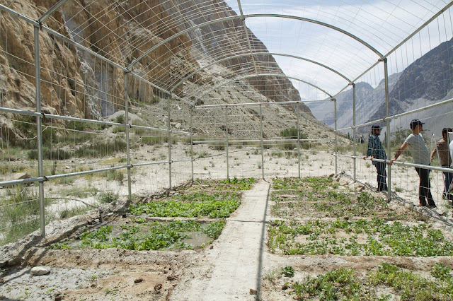
They complained that the covers on the greenhouses they installed quickly blew away in the strong winds. However, their orchard was doing well, and they had a good supply of water. They were still trying to grow some vegetables.
These are the wonderful apricots of Khyber.
Up the road, at Morkhun Sost, we met another group of people. They were also developing land on the opposite side of the river to grow vegetables.
A narrow, dangerous-looking hanging bridge leads to the site where a bit of green is showing in the distance.
We were invited to lunch near Sost, and it was amazing, with an assortment of different types of flatbread, apricot oil, meats, rice, and vegetables.
Our group photo following lunch. Everyone received a hat, including me, but mine was one of the lovely embroidered hats the women wear. Note the gender discrepancy.
As we were leaving the next morning, we noticed there was an unfortunate change in the weather.
On the trip back from Passu the next day, instead of going directly to Hunza, we decided to stop at Hoper village. The green Nagar valley is watered by glaciers in the distance.
Hoper Glacier is a debris-covered glacier; thus, male. The adjoining Barpu glacier is white. There was a bit of a myth about them joining and making a new glacier.Heading back toward Karimabad or Hunza, the clouds were moving in, and it was going to rain.

We drove to the top of Karimabad to stay the night. From the top, there is a wonderful view of the Baltit Fort and the Karakoram highway.
 The water in the Gilgit River was rising, and there was news of many landslides on the Karakoram Highway. We waited a bit more...The next day, we drove to the confluence of the Gilgit River and the Indus River at Juglo, where 4 major mountain ranges meet. The Himalayas to the far right, the Karakorum center, and the Hindu Kush left.


Comments
Post a Comment