
Stilwell Road to Pangsau Pass Festival
Please visit my blog on Southern China - Yunnan Gaoligongshan Nature Reserve in 2015.
Festival highlights
Pangsau Pass is on the border between Arunachal Pradesh and Myanmar. Since 2016, an annual festival has been held to celebrate the tribal groups that straddle the border. To get there, one travels on the Stilwell Road to Nampong.

The Stilwell or Ledo Road was a WWII project that began in December 1942 and ended in May 1945. It was built to connect British India to China in the fight against the Japanese. The photo below shows the treacherous, intestine-shaped road.

General Joseph Stilwell was the American in charge of the project. The road was built to transport supplies from Ledo in Assam to Kunming in China via Pangsau Pass (elevation 1,136m) overland. The pass was the first big obstacle encountered by the engineers in charge of the road. The pass was nicknamed "Hell's Pass" due to frequent landslides.

Pangsau is the name of the village on the Myanmar side of the pass, and Nampong is on the Indian side of the pass. Nampong is where we went for the Pangsau Pass Festival on January 20th, 2020. The Stilwell Road has a rich history that deserves recognition.


In the 1990s, people noticed that local houses were constructed from unusual bricks. When someone got curious and enquired, they found out that the bricks were located in a jungle cemetery, which was overgrown and trampled by wild elephants. When they cleared the jungle, they discovered around 1000 graves.

Most of the graves were plundered before the area could be fenced off and protected. A few of the remaining artifacts were put into a small museum. The men from the Allied forces that are buried here were Chinese, British, Kachin, American, and Indian. They died from malaria, dysentery, landslides, and enemy fire.


The building of the road (11km to Arunachal and 1726km to Kunming) was so difficult near Nampong that one section was called "Hells Gate," which was located in Nampong, the last town on the Indian side.
 The road was built to save the lives of pilots who flew 540km over the "Hump" in the Himalayas to deliver supplies - nearly 1000 men died, and 600 planes were lost in the flight over the "Hump". The planes were called the Flying Tigers.
 At the top of the map, the arrow line shows the flight path over the "Hump". The Sitwell Road is in the upper-middle to the left. The photos of the plane and the map below were taken from the other side of the Hump in Baoshan, China, where we went to the Anti-Japanese Memorial Park in 2014.
 The photo below was taken from a booth that was set up on the Nampong festival grounds.


A few treasure hunters have unearthed relics from WWII over the years. Sometimes they find one of the lost "Flying Tiger" airplanes.


 We arrived at the festival grounds, and it was raining (as usual for our trips). The group from Myanmar had a nice pavilion to stand in while the rain came down.


 The older Naga man in the middle had interesting geometric tattoos. He also wore some kind of large teeth on his necklace and boar's tusks on his hat.
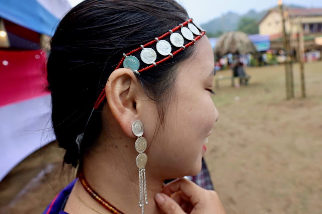
The coins are worn for special occasions like this, and they are very precious.

King Edward VII coins were minted from 1903 to 1910, and they were valued at one rupee; one coin is worth 2000 Indian rupees.
Since we had so much time before the ministers arrived, we visited with different people and admired various tribal ceremonial dresses for the occasion.

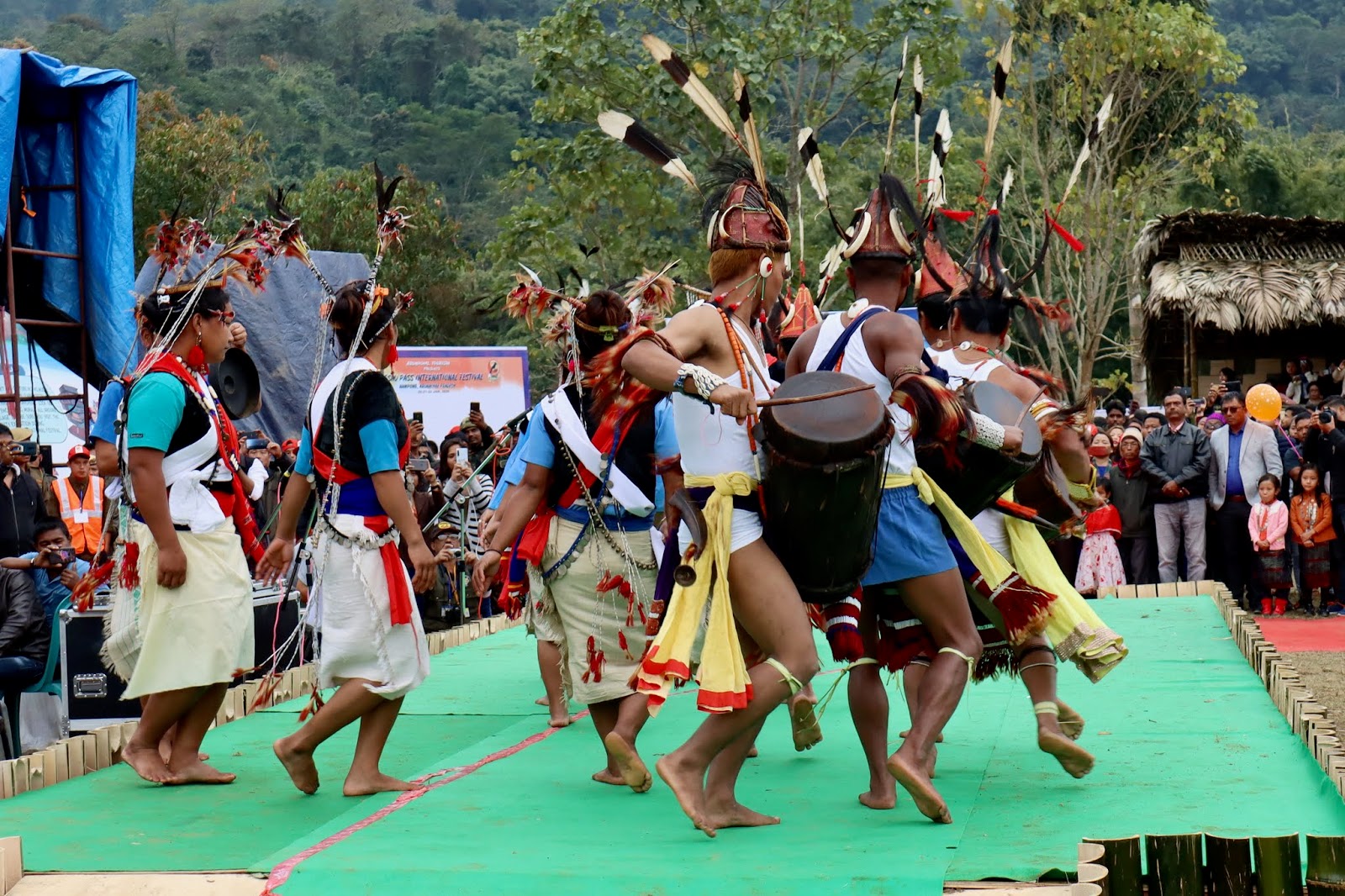
Finally, the festival began, and the dancers were on the stage.

 Lisu are Christians from the Church of Christ. They performed a soft swaying dance to flute music. They originally were from North Myanmar, but some also settled in Vijay Nagar, Arunachal Pradesh. The area is surrounded on three sides by Myanmar and on one side by Namdapha National Park.

 Oops, I think that is a hornbill beak on the dancer's backside.


 There were a lot of Hornbill feathers and wild boar tusks. The dancers were lining up for their turn to dance.


These women are from Myanmar. They were one of the last groups to dance. As you can see behind them, the chairs were empty, and people were under umbrellas.
 We really wanted to visit Pangsau Pass (a distant hill in the photo above) and the Lake of No Return, which is on Myanmar's side. But we were told that, as foreigners, the area was off-limits since it was a sensitive border area. We hope to return for another festival and see the Lake of No Return.
The building of the road (11km to Arunachal and 1726km to Kunming) was so difficult near Nampong that one section was called "Hells Gate," which was located in Nampong, the last town on the Indian side.


A few treasure hunters have unearthed relics from WWII over the years. Sometimes they find one of the lost "Flying Tiger" airplanes.
After a brief visit to the Cemetery, we drove on to the festival.

We had to stop and register for the festival on the road since this is a restricted area of India. There was a big poster at the entry station, which was nowhere near the festival but about 15km from Nampong.

We arrived at the same time the performers were arriving. The whole event was delayed by the rain. The entry gate and everything inside the festival grounds were all made from bamboo. The ministers were coming by helicopter, and they were holding off for better visibility.


The rain didn't stop the Nagas from posing at the main photo point.

Finally, the VIPs arrived, 2 hours late, and the dancers lined up to perform. They were served nice hot drinks, some alcohol, and food. The ministers from Myanmar and the Changlang district were also there.


The coins are worn for special occasions like this, and they are very precious.

King Edward VII coins were minted from 1903 to 1910, and they were valued at one rupee; one coin is worth 2000 Indian rupees.

Since we had so much time before the ministers arrived, we visited with different people and admired various tribal ceremonial dresses for the occasion.

Finally, the festival began, and the dancers were on the stage.
It was hard for us to tell who was from which tribal group, a fewWe
They knew, but for others, it was only a guess.

These guys had real hornbill feathers and wild boar tusks on their hats.


The different ethnic groups are recognized by the fabric patterns in their dresses and their dances.


These women are from Myanmar. They were one of the last groups to dance. As you can see behind them, the chairs were empty, and people were under umbrellas.


Comments
Post a Comment